
www.aero-defence.tech
29
'26
Written on Modified on
Rantizo Introduces Advanced Long Range Fixed Wing Aerial Surveillance Drone
Designed for border security and wildfire monitoring, this high speed electric unmanned aircraft targets commercial availability in mid 2027 across diverse critical infrastructure surveillance missions.
www.rantizo.com
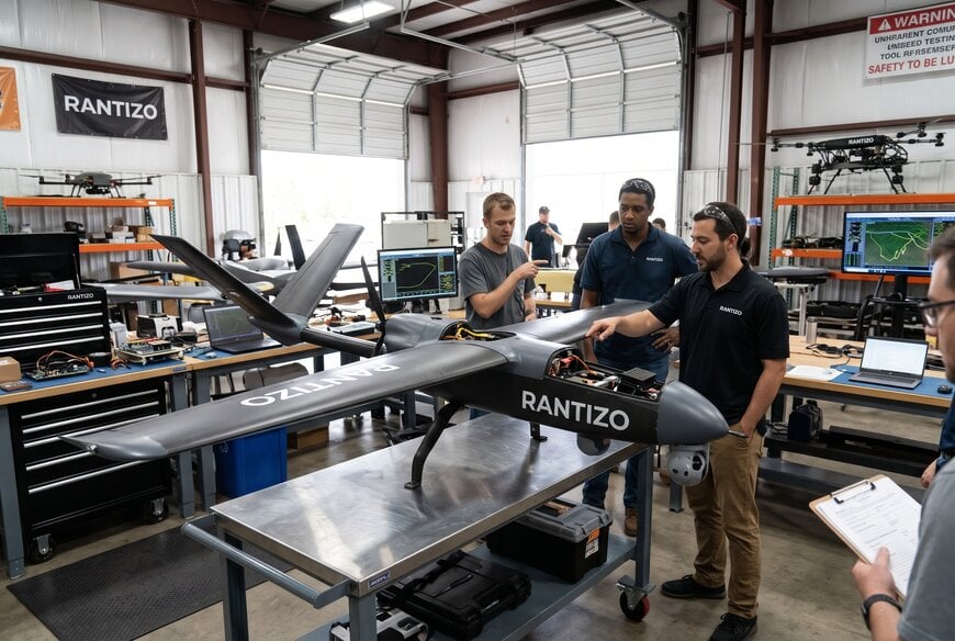
Monitoring vast remote territories, linear infrastructure corridors, and active wildfire zones presents persistent logistical barriers for conventional rotorcraft, which remain constrained by battery endurance and aerodynamic drag. To bridge the gap between short-range multirotor inspections and cost-prohibitive crewed aviation, industrial operators increasingly rely on fixed-wing unmanned aerial systems capable of sustained high-speed transit and continuous aerial intelligence gathering.
Operational Challenges in Wide-Area Industrial Monitoring
Linear infrastructure networks such as oil and gas pipelines, high-voltage transmission lines, and cross-border transport routes require routine observation across hundreds of continuous miles. Traditional multirotor drones excel at stationary, close-proximity asset inspection but lack the lift-to-drag efficiency required to monitor large geographic expanses without frequent battery swaps and ground crew relocation. Conversely, deploying piloted light aircraft or helicopters introduces significant operational expense, carbon emissions, and safety hazards, particularly during low-altitude passes over rugged terrain or active disaster perimeters.
Industrial operators require compact, electric unmanned aircraft platforms that can be rapidly deployed by field personnel, achieve high transit speeds, and operate at altitudes sufficient to maintain continuous situational awareness across varied topography.
Aerodynamic Architecture and Propulsion Mechanisms
Rantizo designed its fixed-wing prototype to address these wide-area inspection requirements using an aerodynamically optimized airframe powered by a high-efficiency battery-driven propulsion system. Unlike rotary configurations that expend substantial energy solely to generate vertical lift, fixed-wing airframes generate lift via forward velocity over aerodynamic wing surfaces, dramatically decreasing power consumption per unit of distance covered.
The prototype features a compact footprint with a 43.9-inch wingspan and a 45.4-inch fuselage length, facilitating field transport and rapid assembly. The electric powertrain delivers a climb rate exceeding 2,000 feet per minute, enabling rapid ascent to operational ceilings above 12,000 feet. The aircraft is engineered for a cruising speed of 43.4 mph and a maximum speed of 75 mph, providing the operational flexibility needed to transit quickly between priority waypoints or loiter efficiently over targeted inspection zones.
Targeted Technical Performance Parameters
The platform incorporates integrated navigation systems combining GPS and LORAN for positioning reliability, alongside an onboard optical payload with automated target-recognition capabilities. Key targeted design specifications for the prototype include:
- Airframe dimensions: 43.9-inch wingspan, 45.4-inch overall fuselage length
- Maximum horizontal velocity: 75 mph
- Cruise speed: 43.4 mph
- Vertical climb capacity: Greater than 2,000 feet per minute
- Operating ceiling: Exceeding 12,000 feet
- Operational range: Greater than 150 miles
- Payload capacity: Greater than 4 pounds
- Power plant: High-efficiency electric battery system
- Positioning architecture: Dual GPS and LORAN integration
- Target identification: Dedicated camera and automated mission-recognition suite
- Radar and acoustic profile: Low detection footprint
Integration Across Commercial and Public Sector Workflows
The platform addresses industrial and public sector operational demands where continuous aerial data collection directly impacts safety and resource allocation.
For pipeline and power grid management, the system enables utility operators to conduct automated corridor surveillance, tracking vegetation encroachment, structural displacement, or physical pipeline damage without placing technicians in hazardous terrain. In forestry and disaster response, the drone provides incident commanders with aerial perimeter mapping, thermal risk assessments, and post-burn damage evaluation during active wildfire suppression.
The payload margin of over 4 pounds allows operators to integrate modular multi-sensor packages, including multispectral cameras, optical zoom sensors, and thermal imagers tailored to border patrol, maritime shoreline reconnaissance, or public safety search-and-rescue operations.
Engineering Perspective and Commercial Roadmap
Marianne McInerney, President of Rantizo, noted that conventional aircraft and ground-based monitoring systems face persistent efficiency limits in remote regions, stating that the development of specialized unmanned aviation platforms is focused on providing field operators with expanded visibility, greater operational reach, and deployment flexibility across critical infrastructure, border security, and environmental protection missions.
Rantizo plans to continue iterative airframe testing, payload integration, and manufacturing scale-up to support a targeted commercial release in mid-2027.
Additional Context
This section details technical specifications and competitive benchmarking not included in the original product announcement.
The transition toward electric small unmanned aircraft systems (sUAS) for beyond visual line of sight (BVLOS) operations reflects broader regulatory and engineering shifts across North America and Europe. Regulatory bodies, including the Federal Aviation Administration (FAA) under emerging Part 108 rulemaking frameworks, are establishing standardized airworthiness and collision avoidance mandates to integrate autonomous platforms into national airspace.
Within the industrial sub-55-pound fixed-wing sector, standard benchmark platforms typically balance wingspans between 40 and 85 inches to reconcile lift generation with field portability. Established benchmark systems in this operational category, such as the senseFly eBee series or the Quantum Systems Trinity tactical platforms, typically offer flight endurance spanning 60 to 90 minutes with operational speeds ranging between 30 and 50 mph. By targeting a maximum velocity of 75 mph and an operating radius exceeding 150 miles on purely electric propulsion, the Rantizo platform aims for higher transit speeds and climb rates than typical mapping-oriented sUAS, aligning its performance closer to tactical tactical intelligence, surveillance, and reconnaissance (ISR) platforms while retaining a compact form factor. The incorporation of terrestrial radio navigation (LORAN) alongside satellite-based GPS reflects an emerging industry focus on resilient position, navigation, and timing (PNT) architectures, ensuring navigational continuity in GPS-contested or satellite-degraded industrial operating environments.
Edited by Evgeny Churilov, Induportals Media - Adapted by AI.
www.rantizo.com
