
www.aero-defence.tech
10
'26
Written on Modified on
Multi-Mission UAS Portfolio for Regional Security
Airbus presents integrated uncrewed systems at FIDAE 2026 to support surveillance, disaster response, and defence operations across Latin America’s diverse environments.
www.airbus.com
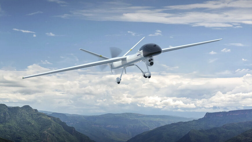
Airbus has introduced a portfolio of uncrewed aerial systems (UAS) designed for multi-mission deployment in Latin America, combining vertical take-off platforms, tactical drones, and long-endurance systems. The solutions target applications in surveillance, firefighting, border control, and maritime security within a broader aerospace data ecosystem.
Adapting UAS capabilities to complex geographies
Latin America’s operational environment spans approximately 20 million square kilometres and includes deserts, rainforests, coastal zones, and mountainous regions. These conditions require flexible aerial platforms capable of operating in remote, infrastructure-limited areas.
Airbus positions its UAS portfolio as complementary to crewed helicopters, enabling hybrid mission architectures where uncrewed systems perform persistent surveillance and data acquisition, while crewed aircraft execute intervention tasks. This division of roles reduces operational risk and improves mission endurance.
The systems were presented at the FIDAE 2026 airshow in Santiago, Chile, reflecting increasing regional demand for integrated aerial surveillance and response capabilities.
Flexrotor: VTOL surveillance for extended operations
The Flexrotor is a tactical vertical take-off and landing (VTOL) UAS designed for intelligence, surveillance, and reconnaissance (ISR) missions. Its compact footprint enables deployment in confined or remote locations, including maritime platforms.
With endurance exceeding 12 hours and a payload capacity of up to 8 kg, the system supports electro-optical sensors and other mission-specific equipment. This allows continuous monitoring of wildfire zones, including nighttime operations where thermal imaging identifies hotspots not visible to ground teams.
The platform’s autonomous take-off and landing capability enables operations without runway infrastructure, supporting rapid deployment across dispersed regions such as the Pampas or wildfire-prone areas in Chile and Brazil.
Aliaca: rapid-deployment ISR for coastal and border security
The Aliaca UAS is optimized for ISR missions in coastal and mixed-terrain environments. Its hybrid propulsion configuration provides an operational range of approximately 100 km, enabling extended surveillance over maritime zones and mountainous regions.
A key operational parameter is its deployment time of approximately 15 minutes, allowing rapid response to emerging security or environmental incidents. The system is suited for monitoring illegal fishing, drug trafficking routes, and maritime pollution, as well as supporting border surveillance.
Its design emphasizes operational agility, making it applicable for countries with extensive coastlines or dual maritime access, where persistent monitoring is required.
SIRTAP: long-endurance tactical system for defence missions
The SIRTAP represents a higher-end tactical UAS platform intended for defence and security operations. With endurance exceeding 20 hours, it supports long-duration missions such as border monitoring, convoy escort, and area surveillance.
The system integrates dual payloads, including an electro-optical turret and a multi-mission radar, enabling simultaneous imaging and detection functions. This configuration supports operations in complex terrains such as the Andes or the Gran Chaco region.
In addition to defence applications, the platform can support search and rescue missions and wildfire monitoring, where long-range coverage and persistent observation are critical.
Integration within a multi-layered aerospace data ecosystem
The three UAS platforms illustrate a tiered operational model, where different endurance levels, payload capacities, and deployment modes are combined to address mission variability. This aligns with the development of an aerospace data ecosystem in which uncrewed systems generate continuous situational data that can be shared across agencies and platforms.
By integrating UAS with crewed aviation assets, operators can achieve continuous coverage, reduce response times, and optimize resource allocation across surveillance, emergency response, and defence missions.
Application scope and operational relevance
The Airbus UAS portfolio is designed for civil protection agencies, defence forces, and law enforcement organizations operating in geographically complex regions. Key application areas include wildfire monitoring, maritime security, border control, and disaster response.
The combination of VTOL capability, rapid deployment, and long-endurance surveillance addresses operational gaps in regions where infrastructure constraints and environmental variability limit traditional aviation approaches.
Edited by an industrial journalist Sucithra Mani with AI assistance.
www.airbus.com
