
www.aero-defence.tech
28
'26
Written on Modified on
Airbus Announces First Pléiades Neo Next Satellite Launch
The new satellite, launching on a Vega C rocket, will deliver 20-cm-class resolution imagery for early 2028 with enhanced Earth observation capabilities.
www.airbus.com
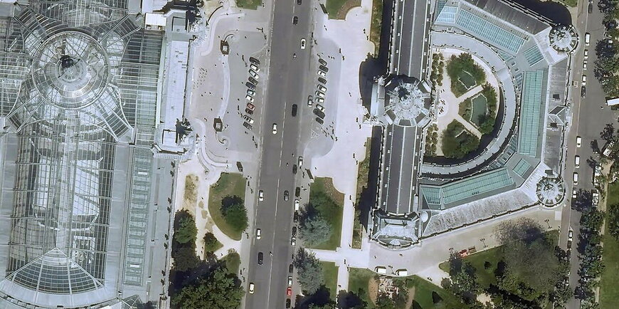
Airbus will launch the inaugural Pléiades Neo Next high-resolution Earth observation satellite in early 2028 from the European Spaceport in Kourou, French Guiana, using an Avio Vega C launch vehicle. This mission is the first operational deployment of the Pléiades Neo Next programme, a strategic expansion of Airbus’s optical Earth observation constellation designed to meet rising global demand for detailed geospatial data.
Technological Enhancements and Imaging Capabilities
The Pléiades Neo Next satellites are engineered to deliver 20-centimetre-class native spatial resolution, meaning that each pixel of imagery corresponds to just 20 cm on the ground. This represents a significant uplift in detail compared with many current very-high-resolution commercial satellites that operate at around 30 cm resolution.
Higher native resolution enables more precise identification and analysis of small features — for example, individual vehicles or infrastructure elements — which is critical for applications such as defence surveillance, disaster response, urban planning, and utilities monitoring. Combined with high geolocation accuracy, such imagery supports both automated analytics and manual interpretation with enhanced situational insight.
Revisit Frequency and Tasking Performance
Airbus designs the Pléiades Neo and Pléiades Neo Next satellites to work in concert. Operating together, they can revisit any location on Earth multiple times per day. This temporal resolution — often also termed “revisit rate” — is essential for monitoring dynamic events such as natural disasters, rapidly evolving security situations, or changes in environmental conditions. Users can task the satellites up to a few dozen minutes before overflight, and imagery is delivered rapidly after acquisition either via customer ground stations (Direct Receiving Stations) or through Airbus’s OneAtlas digital platform.
The programme also includes upgrades to the ground segment and data handling infrastructure to increase image request capacity and reduce the latency from tasking to delivery, improving responsiveness for mission-critical use cases.
Operational Context and Airbus Fleet Integration
Pléiades Neo Next is fully funded, built, and operated by Airbus Defence and Space. Its data products are commercially available across sectors including agriculture, environment, maritime, mapping, and civil infrastructure. By integrating Pléiades Neo Next with Airbus’s existing optical and radar satellite constellations, the broader fleet can deliver complementary services across different resolutions and imaging modalities, including all-weather and day/night capabilities.
Airbus is also advancing additional observational platforms, such as stratospheric systems, to further diversify its Earth observation portfolio.
Differentiation in the Earth Observation Market
The 20 cm class resolution targeted by Pléiades Neo Next places Airbus at the leading edge of commercial optical imaging. Many established commercial Earth observation providers use satellites with approximately 30 cm resolution — for instance, Maxar’s WorldView Legion constellation operates near that level of detail. A finer resolution of 20 cm allows for more granular feature detection and measurement, enhancing the utility of imagery for detailed analysis and decision support in both government and commercial domains.
Moreover, Airbus’s combination of high revisit rates, rapid tasking and delivery, and an integrated digital delivery platform aims to streamline access to data relative to more fragmented supplier ecosystems. The combination of these technical and operational attributes distinguishes Pléiades Neo Next in the competitive landscape of very high resolution satellite imagery.
Implications for Users and Markets
By advancing spatial resolution, revisit frequency, and end-to-end service responsiveness, the Pléiades Neo Next programme addresses key limitations that many organisations face when relying solely on existing Earth observation assets. For users in defence, security, environmental monitoring, and infrastructure planning, this capability expansion supports more detailed situational awareness and enables applications that demand both precision and timeliness of data.
www.airbus.com
